Blogging about the exploration of space seems to be a bit like smoking - even when you know you should quit, you can't. So, very, very quickly: Weird crystals from the Russian mountains:
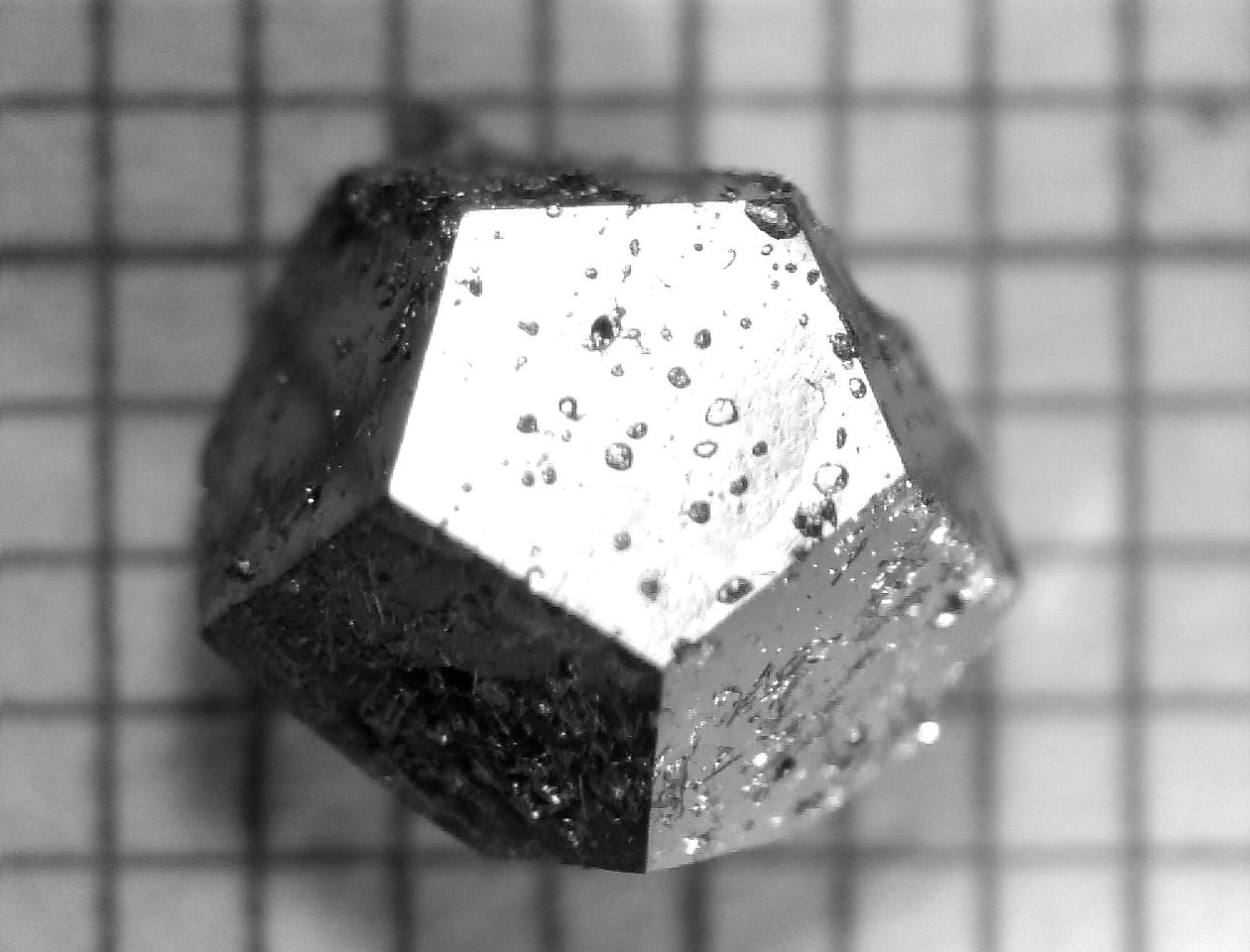
Quasicrystal is a form of matter with crystal structure that can only be fully expressed in higher dimensional space. This strange class of material - that started a minor revolution in materials science when it was discovered - has been confirmed to come from the site of an ancient meteorite impact in the Russian Koryak Mountains. A massive expedition there has found more natural quasicrystals, and further results are on their way. Even more interesting, it seems to be present in carbonaceous chondrite meteorites, which date from the solar systems birth.
"What does nature know that we don't? How did the
quasicrystal form so perfectly inside a complex meteorite when we
normally have to work hard in the laboratory to get anything as perfect?
What other new phases can we find in this meteorite, and what can they
tell us about the early solar system?" Said Paul Steinhardt of Princeton University, who was part of the expedition.
Image above: A piece of lab made quasicrystal. Image courtesy of Stanford University.
Fastest solar storm ever:
The fastest Coronal Mass Ejection ever observed has been seen by NASA's STEREO spacecraft. It was clocked at one percent of lightspeed. If you could ride the front of this blast of particles and radiation it would get you to Pluto's orbit in a little over five weeks.
Video above: A huge, high speed, CME tearing through space. No fart jokes, please. Video courtesy of NASA. Mars has Earth-like geology.
And Mars have a primitive form of plate tectonics, consisting of just two moving plates, that formed the titanic Valles Marineris. The result comes from a paper by An Yin, a UCLA professor, and shows that Mars may resemble a primitive version of Earth geologically.
Image above: The Valles Marineris fault line. Image courtesy of UCLA.
Lastly:
Sunita Williams, an astronaut stationed on the International Space Station, is training to compete in the Nautica Malibu Triathlon in September. She'll still be on the station as she does so, so she will compete using various equipment in the stations gym. Yes, the ISS has gym, in fact it's vital for the astronauts health, but that's another story....
Image above: Sunita, training in the ISS gym. The eighties hair is entirely an artefact of zero gravity, NASA officials say. Image courtesy of NASA tv.
...real life has caught up with me. I'm going to be very short on time for a couple of weeks at least, but I promise I'll be back with something special (not that it isn't all special) as soon as possible! Until then, keep looking at the world, and thinking about it - ultimately that's what people do best...
How's my blogging? Leave some feedback, I get better at this, you get a more interesting read! Or at least fewer spelling mistakes.
Edit: Here's some additional material[0], from the press briefing for the RBSP mission.
It’s tempting to think that the space between the Earth and
the Moon is fairly empty. But a complete map of cis-lunar space would actually be pretty complicated.
There are the satellites in low Earth orbit, medium Earth orbit, high orbit, and
polar orbits. There's the magnetic field of Earth[1] protecting us, the
lucrative geostationary satellite ring[2], thevarious small temporary moons[3] and quasimoons[4] that come and go with time, near earth asteroids that zip past on a
regular basis, the L4 and L5 Lagrange points[5], the geocorona[6]…. It's busy up there - a realm in it's own right.
Image above: A visualisation of the inner and outer Van Allen belts, countless high speed particles caged in the magnetic field of Earth. Enough radiation to kill just about anything, hanging over your head right now. Image courtesy of NASA.
The
belts are made of high energy charged
particles, from the solar wind[8], funnelled into two huge doughnuts by the
magnetic field of Earth:
The inner belt stretches from sixty miles above the surface
(touching the atmosphere over the South Atlantic Anomaly[9]) out to six thousand miles. It's composed of high speed electrons, protons, and smaller numbers of other particle like alpha particles[10] and oxygen ions.
The outer belt stretches from eight thousand four hundred miles out to thirty six
thousand, and is mainly made of electrons. When a solar storm[11] hits it the outer belt inflates with protons from the Sun, that seep down into the inner belt over a day or so. It's a bit like filling a ballot with air, then slowly releasing it, except the balloon is a huge magnetic field, the air is high speed DNA smashing protons[12]... OK, it's not very like filling a balloon with air. But I did only say a bit....
Video above: The Van Allen belts, shown here in cross section, twitching like crazy as a solar storm runs over and through them. The forces at work here are titanic. Yet I can't get past how much it looks like a pair of huge ears flapping about..... Video courtesy of NASA/Goddard.
These belts surround Earth like reefs: They can damage or disable[13] spacecraft that pass through
them when they're active, and many spacecraft do. But they are also an important part of the interplay between Earth, solar storms,
and interplanetary space.
It's worth knowing about them for other reasons to: Most of the universe is made of electrically charged particles[14] (called plasma), funnelled by magnetic fields, just like the belts. These plasmas can even form strange crystals[15], and it's been proposed they might hold life like patterns[16].
Video above: A quick low down on the radiation belts around Earth, and the RBSP twin space craft being sent to explore them. Although it isn't really a low down, these are spaceships, so it's a high up.... ....I'll get my coat. Video courtesy of NASA/Goddard.
Our radiation belts belts are a huge natural plasma lab, and
NASA is taking a closer look: On August the twenty third, the
two octahedral Radiation Belt Storm Probes[17] are being sent into these badlands, to study them up
close. Other missions have done this, but this is the first to use two probes
to get a comprehensive real time view of how the belts act, and using one of
the best suites of sensors ever flown to them.
Image above: One of the RBSP spaceships. A made up image, I assume, unless NASA is employing Dr Who as a photographer now. Image courtesy of NASA.
The RBSP mission will answer questions
like: What mechanism accelerates the particles in the belts to such high speeds? How to they react to coronal mass ejections, and why? What
role do they play in geomagnetic storms and aurora? We have some ideas already, but the RBSP mission will give us a much, much, clearer picture.
And when you're sharing your part of the solar system with two massive, unpredictable, belts of ionising radiation[18] - and you are - a clear picture is a good idea...
Lastly, just because, here's a stunning video of the Earth from space:
Video above: The Earth, as seen from the International Space Station. Just because it's beautiful, and because this is what space missions, like RBSP, are helping us to understand and protect. Video courtesy of NASA.
How's my blogging? Leave some feedback, I get better at this, you get a better read!
While Curiosity is undergoing post landing tests, it appears that the rover may already be in a brilliant spot for learning about the history of water on Mars: The mini sized rover has come down near the edge of an alluvial fan[1] - a spread of debris left by water running down the side of Gale crater.
Based on the MARDI[2] images, the team has put the rovers co-ordinates at 4.5895 S, 137.4417 E. The alluvial fan material is a lag deposit - it was deposited in ancient times, and the weather has blown away the fine grained material, leaving behind a spread of similarly sized pebbles.
This is a nice, simple, patch to understand geologically speaking. Also, it's apparently water related - all of which makes for a nice start to what will, hopefully, be a long mission. Nearby there is an even more interesting spot: A three way junction, between three distinctly different looking kinds of terrain - such unusual locations are often big clues to conditions on a world, millions or billions of years ago.
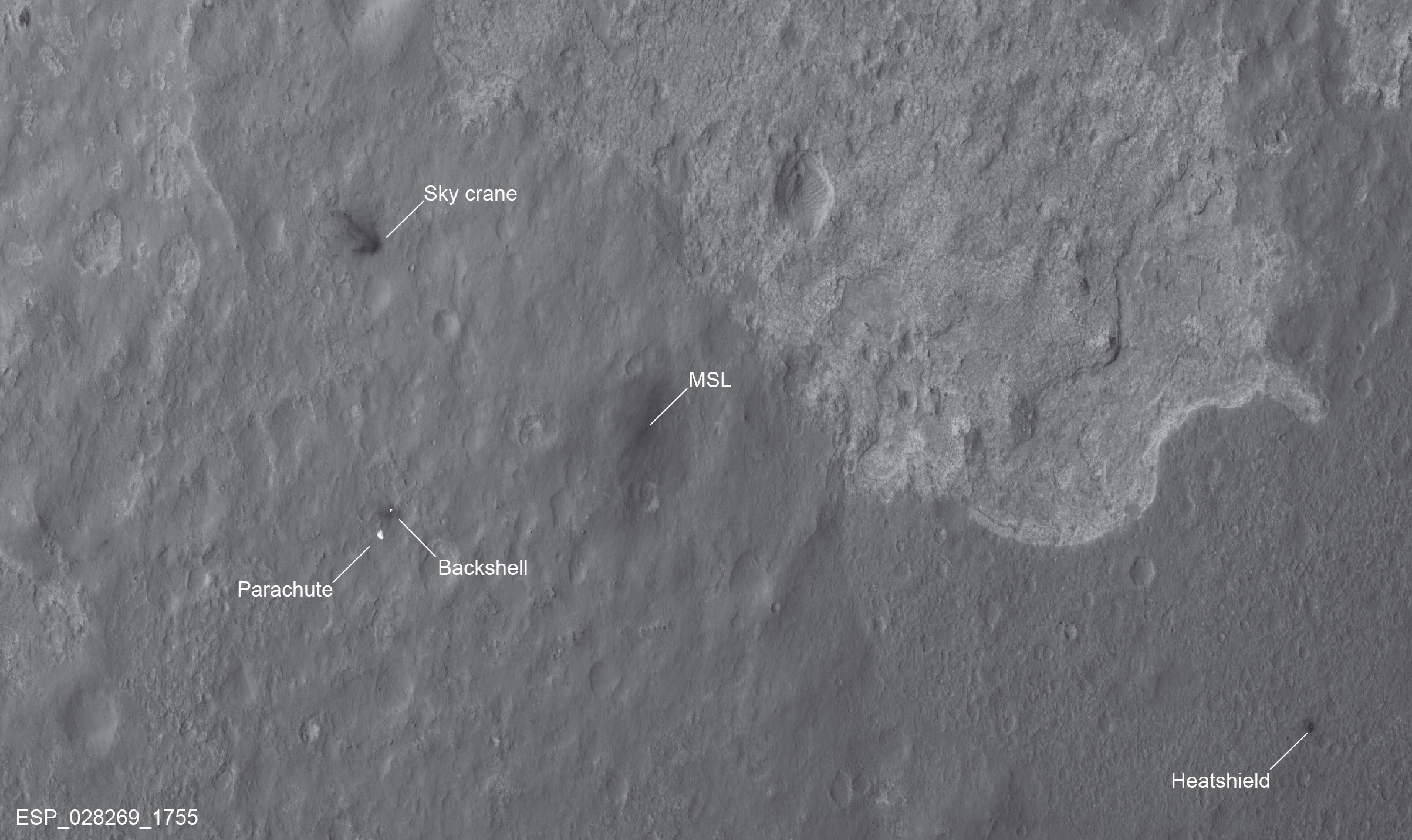
Image above: An image from the MRO orbiter [3], showing the location of Curiosity, and the various spent parts of its landing system. Centre right, you can see the triple junction of different terrains. Image courtesy of NASA.
But, while the robot is designed to rove across the plains of Mars, this spot is potentially full of good science. Or, to quote John Grotzinger, the mission's lead scientist: "This place is awesome. We really don't want to blow out of there."
Image above: The alluvial fan that Curiosity has landed on, with Mount Sharp in the background. From where the rover is at the moment it's a five and a half kilometre trek to the top, which I'd find quite intimidateing. But then, I won't even mow the lawn until I loose sight of the shed. Image courtsey of NASA/JPL.
All of the robots systems have apparently made it through the landing intact, and on the way down the MARDI camera captured this series of images, from the moment the protective backshell was jettisoned, until the rovers wheels hit the dirt:
Video above: The recording from the MARDI camera, of the last minutes of landing. the impact was about on par with the speed of something falling an inch to the ground (on Earth). You can see the dust blown up by the skycranes jets, and it seems that Curiosity is already covered in Martian dust. Never mind, who's going to see? Video courtesy of NASA/JPL.
Lastly, if you've ever wondered if scientists and engineers get a rush out of their work:
Image above: The Curiosity team find out that the lunch van has arrive... I mean, that Curiosity has made it safely to the surface of Mars. Image courtesy of the US government.
How's my blogging? Leave a comment, I get better at this, you get a better read.
Curiosity[3] has landed in Gale crater, within sight of Mount Sharp. Pictures are already coming down, and the talk about the skycrane[1] landing method has changes from " Um... are we really gonna do this?" to "Well, of course it worked, never had any doubts".
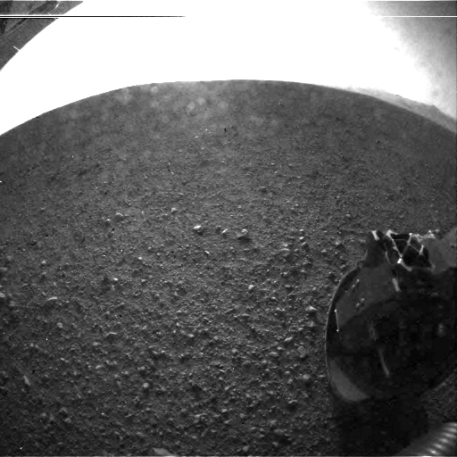
Image above: A first light image from Curiosity. Courtesy of JPL/NASA.
But there is one image I feel like I have to post* - I'm going to refrain from a major post until the Curiosity team have got their bearings, and maybe given a preliminary geologic assesment of the area they're in - but:
Image above: Curiosity, inside it's protective shell, parachuting onto the Martian surface. Image courtesy of JPL.
This shot was taken by the orbiting MRO spaceship[2], as Curiosity parachuted to the surface. Bear in mind, there's no real time, adjust it as you go, controlling of a robot ship near Mars: This was all pre-programmed in, and then the team crossed their fingers and went "!" .
*Yes, I've posted two.
List of links: [1]http://www.space.com/16878-mars-rover-landing-sky-crane-guide.html [2]http://mars.jpl.nasa.gov/mro/ [3]http://mars.jpl.nasa.gov/msl/
How's my bloggin'? Leave some feedback, I get better at this, you get a better read!
The following has been leaked by NASA as a 'loss of mission' scenario that the Curiosity rover team realised, late last night, they hadn't accounted for:
Video above: No rovers were harmed in the making of this video. Video courtesy of Astr0umsf.
...back to reality (I hope that the above can't really happen - at least, not unless Curiosity gets a good camera shot of the Jawa's before they take her down) : Twelve hours until we hit martain atmosphere.
How's my blogging? Leave some feedback, I get better at this, you get a better read!
Well, Curiosity[1] is barely a day away from its rendezvous with Gale crater[2]. I suppose this is like the bit in the movie theatre, when we're all waiting for the film to start. So.. why not check out some upcoming attractions?
The Expendable:
Image above: An artists impression of JUNO at Jupiter. I've gotta be honest: I love the triangular architecture, it's a nice change from the box shapes so many space craft have.Yes, I'm a nerd. NASA/JPL/Caltech.
NASA launched the Juno space probe[3] to Jupiter one year ago today - it still has another four years to go. When it arrives this three point five ton, heavy armoured, robot will brave the lethal radiation environment of Jupiter - which damaged Pioneer 10[4] - to study the depths of the Jovian atmosphere, understand the workings of its water cloud klayer, and determine if the planet has a solid core. In so doing it will be cracking the mystery of how Jupiter formed[5] , and how it arrived at its place in our solar system...
Image above: An infographic on the massive Juno robot. Image courtesy of NASA/Caltech.
Rosetta and its final destination:
Image above: Asteroid Steins, all alone in the black. Aside from the Rosetta spaceship, that is, which was taking the picture. And it's basically a big - if interesting - rock, so I don't think it minds. Image courtesy of ESA.
The ESA space craft Rosetta has already given us some exciting discoveries, encountering and mapping the asteroids Lutetia[6] and Steins[7], and performing a flyby of Mars. .
Image above: A massive landslide on asteroid Lutetia, which has buried part of a crater under a kilometre deep pile of rubble. How that happens on a world where gravity is that weak is an interesting puzzle. Image courtesy of ESA.
But it's aimed at the comet Churyumov - Gerasimenko, a time capsule of
weird materials[8] - some of perhaps relating to the origin of life - from
the birth of our solar system. Rosetta will be the first ship from Earth
to make a long term study of a comet core, and will drop its daughter
ship, Philae, onto the comet to study the surface and geology...
Image above: An artist impression of the Philae lander, at work on the surface of comet Churyumov - Gerasimenko. Isn't that little arm sweet? Too nerdy? OK then. Image courtesy of ESA.
Voyage of the Dawn treads on:
Dawn[9], which has already changed our view of the maimed protoplanet Vesta[10] from this....
Image above: Vesta as seen by the Hubble space telescope. Now, getting a shot like that from (near) Earth is an amazing achievement.But it's kinda fuzzy. Image courtesy of NASA/Hubblesite.org.
....to this....
Image above: Dawn took this shot of where the Vestan south pole should be. what we're seeing here is a double impact crater - one blast on top of another - so huge it deleted the protoplanets entire south pole, and imprinted shock waves into the planets crust as massive ridges. Image courtesy of NASA.
....is about to leave orbit for its next destination: The water-altered dwarf planet Ceres[11]...
Fantastic Voayger...
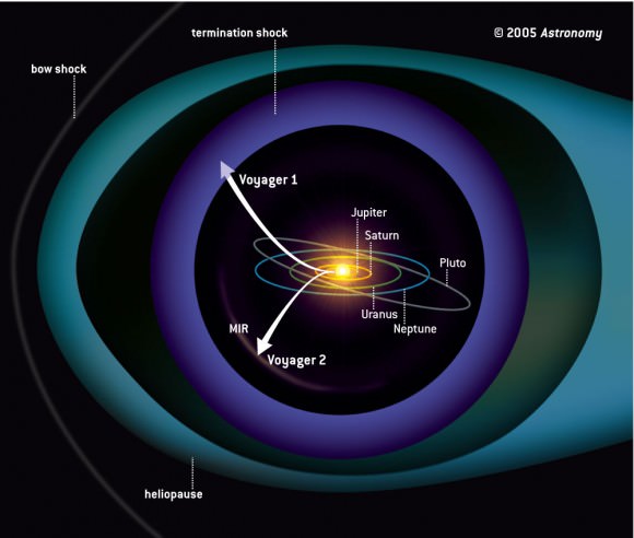
The granddaddy of deep space explorers is right on the edge[12] of leaving our solar system: It's approaching the heliosphere[13], the edge of the magnetic field that surrounds our solar system, and keeps out higher energy cosmic rays.
Image above: A map of the magnetic shield that the Sun blows around our solar system. Seriously, this thing actually keeps a lot of radiation out the inner system where Earth resides. Image courtesy of George K. Park
Voyager two is about to become the first human built spacecraft to enter interstellar space...
Image above: The launch of Voayger two - before I was born, and it's still exploring the universe. I'm a professional* engineer and physicist - that's what we in the trade call 'a nice job'. Image courtesy of JPL/NASA.
The eye...
The biggest eye on the sky ever conceived, the foirty meter wide Extremely Large Telescope[14], has received funding, and is entering the planning stages. This one won't be 'out' for many years yet, but keep watching: with the latest adaptive optics, and such a stonkingly huge main mirror, this telescope will be searching our surrounding galaxy for new planets, new star clusters, nebula... you name it, it's probably on this beasts list of targets somewhere...
Image above: An artists impression of the extremely Large telescope. so called because.. um it's going to be extremely large. I'm waiting for the 'Absurdly Large Telescope', and the 'Now You're Just Being Silly Telescope'. Image courtesy of the European southern Observatory.
Avengers assemble...
What? I liked it. And here's how it should have ended.
And finally:
An optical illusion, from Mars:
Image above: What look a lot like blasted forests, on the dune tops of Mars. But they're not. Sorry. Image courtesy of NASA.
Ye gads! These look like blasted, fossilised trees atop those dunes! Could they really be three billion year old remains from the catastrophe[15] that turned Mars into a hyper-arctic desert...?!
Er, No, they're not. But it's easy to be fooled: These are actually dark streaks on the surface of dunes, caused by dust avalanches rolling down the sides. The avalanches are set off by the evaporation of carbon dioxide ice, as spring approaches.
But! Some other dark streaks[16] on Mars have been put up as possible signs of present day liquid water. Now, let me think, wasn't there something, on it's way to Mars soon, to answer questions about water there...?
* Admittedly, I've blown a few very expensive bits of kit up. And melted a couple more. But then, so has my boss. And so have most of the people I work with. You know, when I was a research student, we had a running tally for who'd given themselves the worst electric shock. The record was about two kilovolts, off what was, basically, a big can full of plasma.... It was a DC shock, so he lived, after flying ten feet through the air. Seriously, if you plan to do science as a career, learn the difference between DC and AC current. British AC is especially deadly. I'm a connoisseur of electric shocks, as well as nerd, go figure.
List of links: [1]http://www.nasa.gov/mission_pages/msl/index.html [2]http://mars.jpl.nasa.gov/msl/mission/timeline/prelaunch/landingsiteselection/galecrater2/ [3]http://www.nasa.gov/mission_pages/juno/main/index.html [4]http://en.wikipedia.org/wiki/Pioneer_10#Encounter_with_Jupiter [5]http://www.nasa.gov/mission_pages/juno/overview/index.html [6]http://www.space.com/13597-asteroid-lutetia-earth-birth.html [7]http://www.spacedaily.com/reports/Rosetta_OSIRIS_Cameras_Reveal_The_Nature_Of_Asteroid_Steins_999.html [8]http://www.springer.com/astronomy/astronomy,+observations+and+techniques/book/978-0-7923-6154-1 [9]http://dawn.jpl.nasa.gov/ [10]http://www.bbc.co.uk/news/science-environment-18027933 [11]http://en.wikipedia.org/wiki/Ceres_%28dwarf_planet%29 [12]http://www.sciencedaily.com/releases/2012/08/120804082858.htm [13]http://helios.gsfc.nasa.gov/heliosph.html [14]http://www.eso.org/public/teles-instr/e-elt.html [15]http://news.sciencemag.org/sciencenow/2009/04/30-02.html [16]http://news.sciencemag.org/sciencenow/2009/04/30-02.html
How's my blogging? Leave some feedback, I get better at this, you get a better read!
Unless you live in a hermetical sealed box, at the bottom of the ocean*, you'll have at least caught a hint that NASA has something big in the works: Sunday is the day that the car sized 'Curiosity' [1] Mars rover lands at Gale crater.
Now, several people at work have ask me: "How's it going to detect life then?"
To which I reply with inarticulate spluttering, but what those splutterings mean is : It's not.
This mission is actually to investigate a world that's been gone for a very, very long time - that we know had a thick atmosphere, and water[2]. That world is the Mars of three and a half billion years ago. Curiosity is going to Gale crater to investigate that Mars, to see if it might have been an environment habitable to life.
Image above: An artists impression of Gale crater, based on data from ESA's Mars
Express orbiter, NASA's Mars
Reconnaissance Orbiter, and the Viking Orbiter. all the heights are times two. They say it's to 'help visualise' things, which means 'because it looks cooler' when I run it through my science speak translatomatic. Image courtesy of NASA/ESA.
Gale is ninety six kilometre wide hole in the Martian crust, formed by a
huge asteroid impact three and a half billion years ago. Doesn't sound very
friendly, no?
But - based on what the small fleet of
probes orbiting Mars can see - Gale crater flooded after it formed, forming a crater lake. The bottom of the lake silted up, and over time, as conditions changed, later layers - both water formed and airborne - have recorded the changes in the Martian environment.
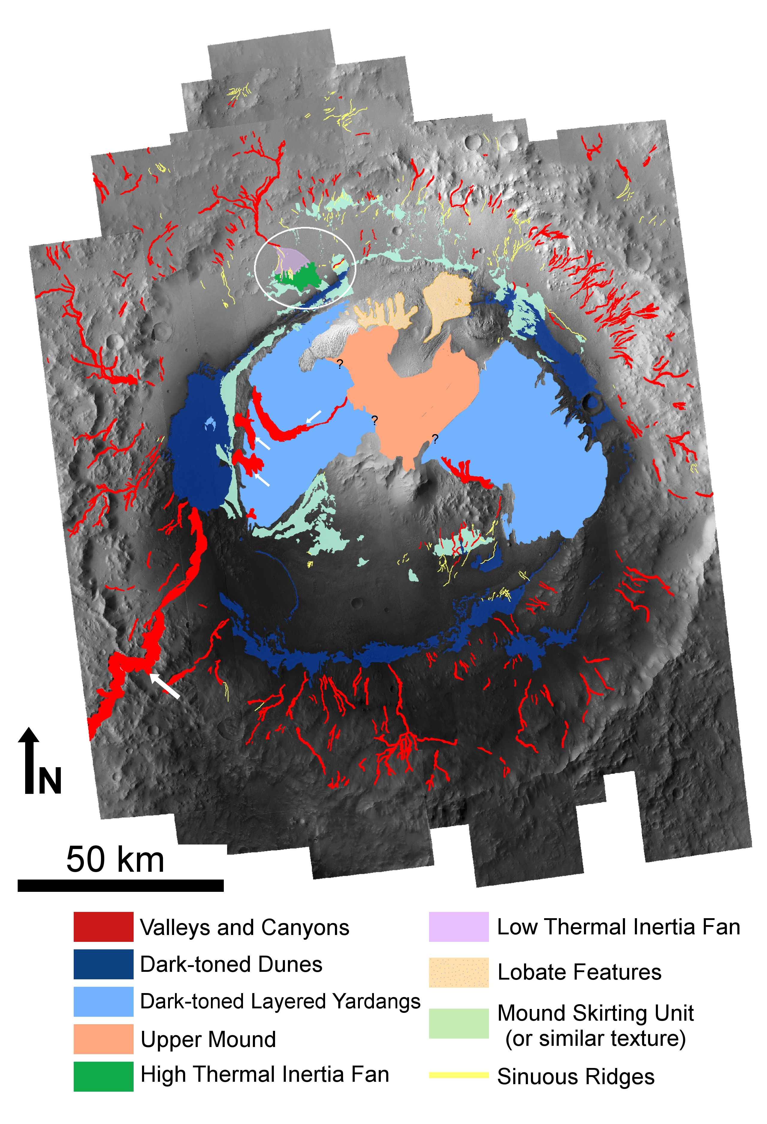
Image above: A map of gale crater, showing heights as colours - you can see that the mountain is higher than much of the crater rim, which shouldn't happen if it is a normal centre-of -crater-mountain. The white ellipse is the landing zone for Curiosity. Image courtesy of Cornell University.
In the centre of the crater is mount Sharp. Now, it's not unusual for impact craters to have a central mountain - the rock literally runs like water[5] under the blast, so it does this.....
Video above: A super slow-mo of a water droplet hitting a water surface. Look at what the 'crater' formed in the water surface by the droplet does: It rebounds into a central column. If you could freeze the water, just at that moment, you'd have something exactly like the crater-and-central-peak formation of an impact crater - the only difference** is that the impact crater does effectively freeze at this point. because the incredibly extreme conditions of the moment of impact fade away.
But Mount Sharp isn't a rebounding rock formation: In fact, Mount Sharp is a bit of a mystery[6]. For one thing it's higher than the rim of the crater - look at the water droplet video again: The peak material that gets that hight, breaks off at the tip.Scale that up, and you can see that the peak would never have got above a certain height.The edges of the crater could have eroded away, but we have other anomalies. For example: The mountain is made of layers[7] - rebound peaks don't form layers. In fact, those bands are important.
They're what Curiosity is travelling to see...
Image above: The layers on the side of Mount Sharp. A layer cake mountain is generally a sign of geology worth taking a peak at. Geddit? Peak/peek? Well I thought it was funny. A bit funny, anyway. Image courtesy of NASA.
Orbiting probes can get some idea[8] of what the materials making Mount Sharp are. The crater floor and lower slopes have phyllosilicates (clay minerals) which almost certainly formed in the presence of liquid water. The mid level slopes have signs of sulfates. Sulfates often mean waters that are acidic[9]. Then the peak is made of a layer of material that seems to have never seen water.
Image above: Some of those layers, as seen from orbit by the HiRISE camera aboard the Mars Reconnaissance Orbiter spaceship. Image courtesy of NASA/JPL.
Which fits with what we know of ancient Mars - we think the planet may have begun with bodies of water that were fairly PH neutral, and benign. This was the time that the clays formed, and if there is any evidence of life supporting chemistry, it should be found there.
Then the planets internal dynamo - its liquid metal core - shut down, for reasons we don't entirely get[13]. This caused the magnetic field to dim, and the solar wind to start eating away[10] at the planets atmosphere. The crust broke open, and massive plumes of magma [11] shouldered their way up out of the dying core. They erupted onto the surface, forming gigantic volcanoes, like Olympus Mons.
Image above: Olympus Mons, surrounded by clouds of water ice. The volcano is the biggest in the solar system. It got that big because the crust on Mars doesn't move about, so a volcano can keep growing and growing, as long as its magma supply is steady. Looks like a big cowpat, doesn't it? Image courtesy of NASA.
The resulting environmental collapse turned much of the Martian waters into diluted acid[12] . But acidic water is still water, and the sediments would still have piled up. So the sediments from these watery epochs formed the first layer of infill.
Eventually the magnetic field died away totally. The atmosphere thinned out. Wind erosion carved out the dried sediments around the crater edge, forming the base of Sharp in the middle. Then the climate shifted (staying dry) and wind began piling stuff into the crater, burying it completely. The wind action then reversed, as the climate shifted yet again, removing the stuff around the rim of the crater again, leaving the mountain sticking out of the middle.
Finally, judging by the patterns on the crater floor, there might have been a last phase of liquid water - it's hard to form large amounts of liquid water on modern Mars, but not impossible. A last gasp of magma for example, rising under a buried ice deposit, would do it.
Image above: Another map of Gale crater, showing some of the geological features. Notice the Valley and canyons running down the crater walls? they're a good sign that water was flowing into the crater at one point. The dark green 'fan' could be a brief splash of water from more modern times, which is why the landing zone is right over it. Image courtesy of marsjournal.org.
That's the theory - Curiosity will test it.
So Curiosity is just another step along the road to finding the answers about life on Mars. One step at a time Ladies and Gents - if we rush things, we'll make mistakes...
* In fact, since you are reading this, your box clearly has the internet, and you've probably heard anyway.
** Aside from the impact crater being a squillion times bigger, forming at thousands of degrees Celsius, forming out of molten rock not water, and the heat pulse from the water droplet doesn't incinerate a whole continent, the waves from the droplet aren't three hundred meters high as they hit the shore, and astronomers don't sometimes wake up at three in the morning in a cold sweat because of water droplets.
List of links: [1]http://www.marsdaily.com/reports/Nicaraguan_Volcano_Provides_Insight_Into_Early_Mars_999.html [2]http://news.discovery.com/space/mars-water-mineral-rover-111208.html [3]http://mars.jpl.nasa.gov/msl/mission/timeline/prelaunch/landingsiteselection/galecrater2/ [4]http://www.esa.int/esaCP/SEM5O1TX55H_index_0.html [5]http://articles.adsabs.harvard.edu/cgi-bin/nph-iarticle_query?bibcode=1991LPI....22..617I&db_key=AST&page_ind=0&data_type=GIF&type=SCREEN_VIEW&classic=YES [6]http://www.nature.com/news/crater-mound-a-prize-and-puzzle-for-mars-rover-1.11122 [7]http://www.geo.umass.edu/courses/geo892/Gale_Sed.pdf [8]http://marsoweb.nas.nasa.gov/landingsites/msl/workshops/5th_workshop/talks/Tuesday_AM/Vaniman_May_2011_Landing_Site_Workshop.pdf [9]http://astrobiology.berkeley.edu/PDFs_articles/Geology_Aubreyetal5_06.pdf [10]http://science.nasa.gov/science-news/science-at-nasa/2001/ast31jan_1/ [11]http://www.geolsoc.org.uk/gsl/education/flood_basalts_1 [12]http://www.marsdaily.com/reports/Nicaraguan_Volcano_Provides_Insight_Into_Early_Mars_999.html [13]http://www.newscientist.com/article/dn11962-lab-study-indicates-mars-has-a-molten-core.html